A couple of years ago, I wrote about a commonly cited method of direction-finding using an analog watch and the sun. Briefly, if you hold your watch face horizontally with the hour hand pointing toward the sun, then the ray halfway between the hour hand and 12 noon points approximately true south. (This is for locations in the northern hemisphere; there is a slightly different version that works in the southern hemisphere.)
The punch line was that the method can be extremely inaccurate, with errors potentially exceeding 80 degrees depending on the location, month, and time of day. I provided a couple of figures, each for a different “extreme” location in the United States, showing the range of error in estimated direction over the course of an entire year.
Unfortunately, I ended on that essentially negative note, without considering any potentially more accurate methods as an alternative. This post is an attempt to remedy that. In recent discussion in the comments, Steve H. suggested analysis of the use of the “shadow-stick” method: place a stick vertically in the ground, and mark the location on the ground of the tip of the stick’s shadow at two (or more) different times. The line containing these points will be roughly west-to-east.
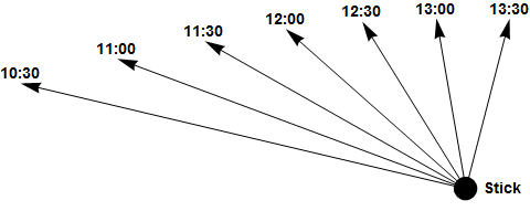
Illustration of the shadow-stick method of direction-finding. With a stick placed vertically in the ground, the tip of the stick’s shadow moves roughly from west to east.
As the following analysis shows, this shadow-stick method of direction-finding is indeed generally more accurate than the watch method… most of the time, anyway. But even when it is better, it can still be bad. It turns out that both methods are plagued with some problems, with the not-so-surprising conclusion that if you need to find your way home, there is a tradeoff to be made between accuracy and convenience.
One of the problems with my original presentation was condensing the behavior of the watch method over an entire year into a single plot (in this case, at Lake of the Woods in Minnesota, at a northern latitude where the watch method’s accuracy is best). This clearly shows the performance envelope, i.e. the maximum possible error over the whole year, but it hides the important trending behavior within each day, and how that daily trend changes very gradually over the year. We can see this more clearly with an animation: the following shows the same daily behavior of error in estimated direction using the watch method (in blue), but also the shadow-stick method (in red), over the course of this year.
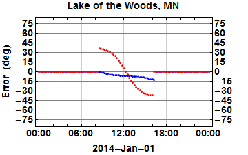
Accuracy of the watch method (blue) and shadow-stick method (red) of direction-finding, over the course of the year 2014 in Lake of the Woods, Minnesota. The shadow-stick method is more accurate 40.6% of the time.
For reference, following are links to a couple of other animations showing the same comparison at other locations.
- Florida Keys (a southern extreme, where the watch method performs poorly, included in the original earlier post)
- Durango, Colorado (discussed in the comments on the earlier post)
There are several things to note here. First, this is an example where the shadow-stick method can actually perform significantly worse than the watch method. Its worst-case behavior is near the solstices in June and December, with errors exceeding 30 degrees near sunrise and sunset. This worst-case error increases with latitude, which is the opposite of how the watch method behaves, as shown by the Florida Keys example above.
However, note the symmetry in the error curve for the shadow-stick method. It always passes from an extreme in the morning, to zero around noon, to the other extreme in the evening. We can exploit this symmetry… if we are willing to wait around a while. That is, we could improve our accuracy by making a direction measurement some time in the morning before noon, then making another measurement at the same time after noon, and using the average of the two as our final estimate. (A slightly easier common refinement of the shadow-stick method is to (1) mark the tip of the shadow sometime in the morning, then (2) mark the shadow again later in the afternoon when the shadow is the same length. The basic idea is the same in either case.)
Finally, this issue of the length of time between measurements is likely an important consideration in the field. A benefit of the watch method is that you get a result immediately; look at the sun, look at your watch, and you’re off. The shadow-stick method, on the other hand, requires a pair of measurements, with some waiting time in between. How long are you willing to wait for more accuracy?
Interestingly, the benefit of that additional waiting time isn’t linear– that is, all of the data shown here assumes just 15 minutes between marking the stick’s shadow. Waiting longer can certainly reduce the effect of measurement error (i.e., the problem of using cylindrical sticks and spherical pebbles, etc., instead of mathematical line segments and points) by providing a longer baseline… but the inherent accuracy of the method only improves significantly when the two measurement times span apparent noon, as in the refinement above, which could take hours.
To wrap up, I still do not see a way to condense this information into a reasonably simple, easy-to-remember, expedient method for finding direction in the field without a compass. The regular, symmetric behavior of the error in the shadow-stick method suggests that we could possibly devise an “immediate” method of eliminating most of that error, by considering the extent and sense of the error as a function of the season, and a “scale factor” as a function of the time until/since noon… but that starts to sound like anything but “simple and easy-to-remember.”


